


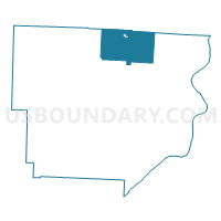
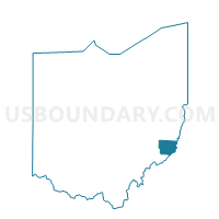
PRECINCT SUNSBURY, Monroe County, Ohio
About
Outline

Summary
| Unique Area Identifier | 650130 |
| Name | PRECINCT SUNSBURY |
| County | Monroe County |
| State | Ohio |
| Area (square miles) | 28.12 |
| Land Area (square miles) | 28.11 |
| Water Area (square miles) | 0.01 |
| % of Land Area | 99.98 |
| % of Water Area | 0.02 |
| Latitude of the Internal Point | 39.81775670 |
| Longtitude of the Internal Point | -81.03274450 |
Maps

Graphs
Select a template below for downloading or customizing gragh for PRECINCT SUNSBURY, Monroe County, Ohio


Neighbors
Neighoring Voting District (by Name) Neighboring Voting District on the Map
- PRECINCT ADAMS, Monroe County, OH
- PRECINCT BEALLSVILLE, Monroe County, OH
- PRECINCT CENTER NORTH, Monroe County, OH
- PRECINCT MALAGA EAST, Monroe County, OH
- PRECINCT SWITZERLAND, Monroe County, OH
- Voting District WASHINGTON TOWNSHIP, Belmont County, OH
- Voting District WAYNE TOWNSHIP, Belmont County, OH
Top 10 Neighboring County Subdivision (by Population) Neighboring County Subdivision on the Map
- Center township, Monroe County, OH (3,647)
- Sunsbury township, Monroe County, OH (1,325)
- Malaga township, Monroe County, OH (1,062)
- Wayne township, Belmont County, OH (709)
- Adams township, Monroe County, OH (625)
- Washington township, Belmont County, OH (517)
- Switzerland township, Monroe County, OH (462)